
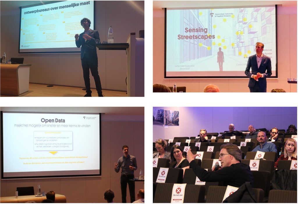
The Sensing Streetscapes research project team shares the final results and goes on an excursion to four cities with design solutions at the eye level
The popularity of the city continues unremittingly, and this can be seen in contemporary building projects: they get higher and higher now that the city is densifying. From London to Oslo and from Vancouver to Amsterdam. Within the framework of the Sensing Streetscapes research project, the Chair of Spatial Urban Transformation at the Amsterdam University of Applied Sciences (AUAS) together with design firms, municipalities, developers and housing corporations researched how to create a human scale in high-density developments. The researchers used Research through Design, neuroarchitecture and AI to achieve this. What practical lessons were learned from this two-year research project, and what insights did the researchers gain concerning this very topical issue?
Researchers involved in the Sensing Streetscapes action research project analysed design solutions to proportion high-rise buildings to a human scale at eye level in Amsterdam, Vancouver, Toronto, Manchester, London and Oslo. Because both the design task and the methodology of neuroarchitecture are a novelty in the Netherlands, they worked together with international partners and cities around the world. The analyses show solutions that were applied for the same urban planning rules. This made major differences visible.
Looking as a Professional: Six Case Studies Researched through Design
While Toronto presents itself with hard and extreme choices that literally exhibit high-rise buildings at the street, other cities such as Vancouver, Manchester and Amsterdam are far more layered. Above all, more details have been used, making the high rise visually less impactful for street users. This is indeed necessary, because a human scale at street level improves the liveability of high-rise locations and improves health and stress-related symptoms associated with these environments.
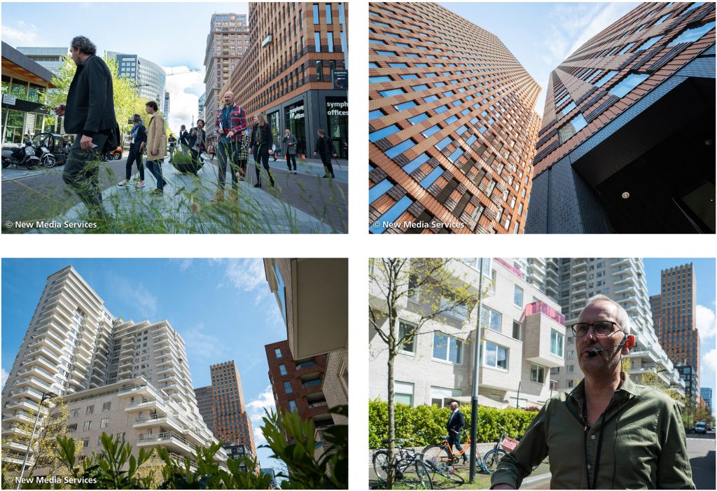
An excursion to the mixed-use Zuidas in Amsterdam provided an example of successful high rise, explains Frank Suurenbroek, Professor of Spatial Urban Transformation at the Centre of Expertise Urban Technology (AUAS). ‘The connection between the functionalism of offices and the soft materials for residential buildings has largely been successful here. There is also a lot of vegetation in the form of beautiful pocket parks that are partly open to the public and that were even designed with the residents.’ International experts ‘flew in digitally’ and many of those involved in the field in the Netherlands (from design firms to developers, as well as organisations representing professionals and senior designers from the Netherlands’ largest cities) were present for the excursion. It was part of the concluding seminar, during which the knowledge acquired after two years of research was presented.
It became clear that residents in high-rise buildings on the Isle of Dogs peninsula in London sometimes live in social isolation because they have little contact with neighbours and the street. By contrast, similar environments in Amsterdam, Vancouver and Oslo present a different picture thanks to their natural surroundings. ‘The last few years have demonstrated that vegetation has become an important pillar of design,’ explains Gideon Spanjar, project leader of Sensing Streetscapes. ‘Residents in high-rise buildings in Vancouver have a view of nature and small- and large-scale buildings have been deliberately mixed. Designers also work with design solutions that withdraw high-rise buildings from pedestrians’ view by receding the buildings so that tree canopies subtly demarcate the space. We also refer to this as Vancouverism.’
Looking as a User: Neuroarchitecture Unlocks Experience
But how do residents themselves experience eye-level design solutions? The new discipline of neuroarchitecture provides the possibility of answering this for the first time. Everyone knows places that feel pleasant and places they want to leave as soon as possible. Neuroarchitecture makes this process visible with the aid of eye-trackers and a specially designed biometric dashboard. At the rate of 30 times a second, the eye-trackers register what a user looks at, for how long and in which order. By systematically presenting different locations to a large number of subjects, patterns become visible on a heat map (an example is the main photograph on the Neuroarchitecture page).
The field and laboratory tests show the importance of what is designed at eye level, as the designers predicted. In particular, it became clear that subjects look for other people, scanning the space where they might be expected, such as balconies, porches, entrances, bicycle racks and cars, as well as the functions on the ground floor and the material of the buildings. And while too much complexity in a street draws attention in a negative sense, both a closed and a transparent plinth are less striking. The contours of an elevated plinth are actually being seen and help to scale down high-rise buildings. Finally, a gradual transition between the street facade and the street space also works well.
The balance between successful and unsuccessful design solutions is subtle, explains Professor Suurenbroek. ‘If we want to ensure that people aren’t overwhelmed by high-rise buildings, then neuroarchitecture tests during the design process are important. The method developed and the patterns that it makes visible show that it can really inform us about the impact of design choices.’
Looking Based on Data: AI Unlocks a Series of Informative Locations
Every building task within the existing city presents unique challenges, but examples of successfully implemented designs can serve as references for the impact of possible design solutions. As part of the research project, AI was used to build a search engine that makes it possible to trace comparable locations through open data. AI helps spatial designers and commissioning parties to find a large number of appropriate reference locations from all across Europe and North America. The amount of high rise, Floor Space Index, and mixed use are just a few of the parameters the user can adjust as needed.
Frank Suurenbroek: ‘Once built, a spatial project determines the appearance and conditions of a location and the surroundings for decades. This is precisely why we have tried to use our research and the excursion to facilitate a dialogue between designers, clients, future users and international experts. Moreover, Amsterdam’s growth shows many similarities to that of most other western cities. Research through Design, neuroarchitecture, the AI tool and excursions are invaluable in this context. After all, designing the street level partly falls in the domain of different disciplines.’
More Information
The final seminar and the excursion were part of the two-year Sensing Streetscapes research project. Frank Suurenbroek, Professor of Spatial Urban Transformation, senior researcher Gideon Spanjar, and senior AI researcher Maarten Groen (Responsible IT research programme) shared their results, as did experts from Oslo, Vancouver and London. Within the framework of the project, an interdisciplinary team of researchers is working together with professionals from the field and international research groups to analyse the concept of the human scale for spatial design. This platform has been built for those interested to see the results and use the AI open-access tool.